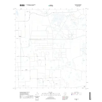
2019 Map of Willamar
USGS Topo · Published 2019About this map
The agricultural grid of Willacy County is the primary characteristic of this landscape near the small settlements of Willamar and Porfirio. A complex network of county roads and farm-to-market routes, including FM 1420 and FM 490 E, partitions the flat Texas coastal plain into large rectangular plots. The scarcity of natural surface water is managed through numerous reservoirs such as Sacatosa Tank, Retamita Tank, and Long Hill Tank, while the North Floodway provides essential drainage for the region. Genealogists can identify significant local burial sites at El Toro Cem and La Jarita Cem, which sit along the edges of these vast tilled fields. The presence of roads like Wild Life Rd and Citation Rd suggests the varied uses of the land beyond traditional farming, reflecting the modern layout of the Rio Grande Valley hinterlands.
Find a feature on this map
31 named features on this map. Tap any name to fly to it.
Don’t see what you’re looking for? This feature index may not catch every label — zoom into the map to look around manually.
Map Details
Editions of this 2019 Willamar Map
This is the sole edition of this map. No revisions or reprints were ever made.
Other maps of this area

1921 · Tarida Ranch
USGS Topo · 1:62,500

1930 · La Leona
USGS Topo · 1:24,000

1932 · Combes
USGS Topo · 1:31,680

1933 · Paso Real
USGS Topo · 1:31,680

1936 · La Leona
USGS Topo · 1:31,680

1952 · Hawk Island
USGS Topo · 1:24,000

1952 · Port Mansfield
USGS Topo · 1:24,000

1952 · South of Potrero Lopeno
USGS Topo · 1:62,500

1953 · Brownsville
USGS Topo · 1:250,000
1955 · La Leona
USGS Topo · 1:62,500