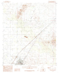
1985 Map of Willcox North
USGS Topo · Published 1985About this map
Willcox sits at the southern edge of this Arizona basin, serving as a hub for the Southern Pacific railroad during the mid-1980s. The landscape transitions from the developed streets of the town, featuring landmarks like the Radio Tower KHIL and a Trailer Park, into the high desert topography of the Circle Hills and the northern slopes of the Dos Cabezas Mountains. The drainage patterns of Campomocho Draw lead toward the expansive Alkali Flat, illustrating the arid hydrology of the region. Small outcroppings such as the Spike E Hills and Double Wood Point break the basin floor, while the settlement of Raso marks a point along the railroad and a major Pipeline corridor to the northeast. This provisional survey captures the intersection of transportation infrastructure and the desert environment before modern expansion.
Find a feature on this map
15 named features on this map. Tap any name to fly to it.
Don’t see what you’re looking for? This feature index may not catch every label — zoom into the map to look around manually.
Map Details
Editions of this 1985 Willcox North Map
2 editions found
Other maps of this area

1922 · Willcox
USGS Topo · 1:125,000

1943 · Dos Cabezas
USGS Topo · 1:62,500

1943 · Willcox
USGS Topo · 1:62,500

1943 · Cochise
USGS Topo · 1:62,500

1944 · Fisher Hills
USGS Topo · 1:62,500

1954 · Silver City
USGS Topo · 1:250,000

1957 · Dos Cabezas
USGS Topo · 1:62,500

1957 · Luzena
USGS Topo · 1:62,500

1958 · Silver City
USGS Topo · 1:250,000

1958 · Willcox
USGS Topo · 1:62,500