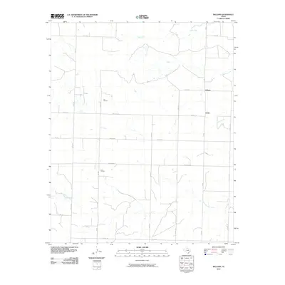
2010 Map of Williams
USGS Topo · Published 2010About this map
Elba Cemetery and Scott Cemetery anchor this rural landscape in Hardeman County, reflecting the deep-rooted family lineages that settled the plains of North Texas. The settlement of Williams sits at the junction of FM 680 and Horton Rd, serving as a central point in a vast grid of farm-to-market roads and section lines. The terrain is defined by a network of drainage systems, including the winding course of Tepee Creek and Papoose Creek in the north, and North Groesbeck Creek flowing through the southern portion of the quadrangle. For genealogists and local historians, the presence of multiple cemeteries, including the Johnson Cemetery near Squaw Creek, offers a precise record of early community sites that often outlast the small settlements they once served. The map's detailed road network, featuring names like Nippert Rd and Howeth Rd, illustrates the legacy of land ownership and local travel routes in this agricultural region.
Find a feature on this map
24 named features on this map. Tap any name to fly to it.
Don’t see what you’re looking for? This feature index may not catch every label — zoom into the map to look around manually.
Map Details
Editions of this 2010 Williams Map
This is the sole edition of this map. No revisions or reprints were ever made.
Other maps of this area

1954 · Plainview
USGS Topo · 1:250,000

1955 · Lawton
USGS Topo · 1:250,000

1958 · Plainview
USGS Topo · 1:250,000

1960 · Goodlett
USGS Topo · 1:62,500

1960 · Loco
USGS Topo · 1:62,500

1961 · Hollis
USGS Topo · 1:62,500

1967 · Kirkland South
USGS Topo · 1:24,000

1967 · Kirkland North
USGS Topo · 1:24,000

1975 · Hollis SE
USGS Topo · 1:24,000
1984 · Quanah West
USGS Topo · 1:24,000