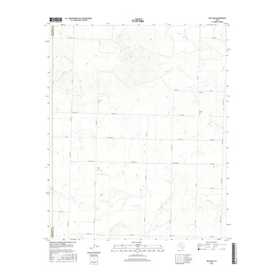
2016 Map of Williams
USGS Topo · Published 2016About this map
The rolling plains of Hardeman County and neighboring Childress County are defined by a network of intermittent creeks and rural section roads. Small family or community burial sites like Elba Cem, Scott Cem, and Johnson Cem serve as the primary markers of historical settlement in this expansive ranching and farming landscape. Near the settlement of Williams, several waterways including Papoose Cr and Popoose Cr drain toward the east, while N Groesbeck Cr meanders through the southern portion of the sheet. The layout of the land is strictly organized by a grid of named routes, such as Lindsey Rd, Mitchell Rd, and McSpadden Rd, reflecting the methodical subdivision of the Texas Panhandle. This survey provides a clear view of the sparse but persistent human footprint on the land, where named features are often limited to long-standing family landholdings and small rural crossroads.
Find a feature on this map
30 named features on this map. Tap any name to fly to it.
Don’t see what you’re looking for? This feature index may not catch every label — zoom into the map to look around manually.
Map Details
Editions of this 2016 Williams Map
This is the sole edition of this map. No revisions or reprints were ever made.
Other maps of this area

1954 · Plainview
USGS Topo · 1:250,000

1955 · Lawton
USGS Topo · 1:250,000

1958 · Plainview
USGS Topo · 1:250,000

1960 · Goodlett
USGS Topo · 1:62,500

1960 · Loco
USGS Topo · 1:62,500

1961 · Hollis
USGS Topo · 1:62,500

1967 · Kirkland South
USGS Topo · 1:24,000

1967 · Kirkland North
USGS Topo · 1:24,000

1975 · Hollis SE
USGS Topo · 1:24,000
1984 · Quanah West
USGS Topo · 1:24,000