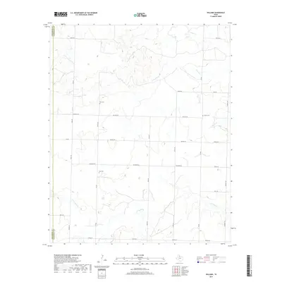
2019 Map of Williams
USGS Topo · Published 2019About this map
Hardeman County's rural landscape is defined by the winding paths of several intermittent waterways, most notably N Groesbeck Cr and Tepee Cr. The terrain in this corner of North Texas is marked by a network of farm-to-market roads and local routes like FM 268 and Nippert RD, which connect scattered homesteads and agricultural plots. This map serves as a vital record for family history researchers, documenting the location of local burial grounds such as Elba Cem, Scott Cem, and Johnson Cem. These small cemeteries are often the primary landmarks in an area dominated by dry creek beds like Papoose Cr and Squaw Cr. The county line between Childress County and Hardeman County runs along the western edge of the quadrangle, illustrating the geographic boundary that separates these two Panhandle regions.
Find a feature on this map
29 named features on this map. Tap any name to fly to it.
Don’t see what you’re looking for? This feature index may not catch every label — zoom into the map to look around manually.
Map Details
Editions of this 2019 Williams Map
This is the sole edition of this map. No revisions or reprints were ever made.
Other maps of this area

1954 · Plainview
USGS Topo · 1:250,000

1955 · Lawton
USGS Topo · 1:250,000

1958 · Plainview
USGS Topo · 1:250,000

1960 · Goodlett
USGS Topo · 1:62,500

1960 · Loco
USGS Topo · 1:62,500

1961 · Hollis
USGS Topo · 1:62,500

1967 · Kirkland South
USGS Topo · 1:24,000

1967 · Kirkland North
USGS Topo · 1:24,000

1975 · Hollis SE
USGS Topo · 1:24,000
1984 · Quanah West
USGS Topo · 1:24,000