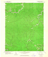
1965 Map of Williams Mountain
USGS Topo · Published 1966About this map
Williams Mountain stands as a central landmark in this portion of Boone County, where the landscape is defined by the deep V-shaped valleys of the Laurel Creek and Drawdy Creek systems. In the mid-1960s, the region's economy and social structure are clearly anchored by the Chesapeake and Ohio railroad and the numerous Strip Mine operations carved into the hillsides. The map documents a scattered but persistent network of family history, evidenced by several small graveyards such as Bias Cem, Harless Cem, and Jarrells Cem tucked into the hollows near settlements like Prenter and Andrew. The presence of the Jarrells Lookout Tower atop the ridges highlights the importance of fire observation in this heavily wooded terrain, while Atha Chapel and small clusters of homes along Hopkins Fork reflect the community centers of the era.
Find a feature on this map
55 named features on this map. Tap any name to fly to it.
Don’t see what you’re looking for? This feature index may not catch every label — zoom into the map to look around manually.
Map Details
Editions of this 1965 Williams Mountain Map
3 editions found
Other maps of this area

1891 · Oceana
USGS Topo · 1:125,000

1893 · Oceana
USGS Topo · 1:125,000

1898 · Oceana
USGS Topo · 1:125,000

1899 · Charleston
USGS Topo · 1:125,000

1909 · Peytona
USGS Topo · 1:48,000

1910 · Bald Knob
USGS Topo · 1:48,000

1911 · Peytona
USGS Topo · 1:62,500

1911 · Madison
USGS Topo · 1:62,500

1912 · Bald Knob
USGS Topo · 1:62,500

1913 · Logan
USGS Topo · 1:62,500