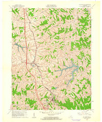
1961 Map of Williamstown
USGS Topo · Published 1962About this map
Williamstown Lake dominates the central landscape of this early 1960s study, its many fingers stretching into the dendritic valley system south of Dry Ridge. The ridge-top settlement patterns of Grant County are clearly defined by the path of the Southern railroad and the Bannister Pike, where small communities like Sherman grew alongside the tracks. Genealogists will find a high density of rural burial grounds, including the Baton Rouge Cem, Hill Crest Cem, and McGuinnis Cem, often situated near local landmarks like Mt Zion Ch. Cultural details of the mid-century era are captured through the presence of a Drive-in Theater near the highway and the County High Sch in Williamstown. The map illustrates a transition toward modern water management with Railroad Lake and Bullock Pen Lake supplementing the older creek-side settlements.
Find a feature on this map
37 named features on this map. Tap any name to fly to it.
Don’t see what you’re looking for? This feature index may not catch every label — zoom into the map to look around manually.
Map Details
Editions of this 1961 Williamstown Map
2 editions found
Other maps of this area

1929 · Alexandria
USGS Topo · 1:48,000

1930 · Falmouth
USGS Topo · 1:48,000

1936 · Alexandria
USGS Topo · 1:62,500

1936 · Falmouth
USGS Topo · 1:62,500

1950 · Mason
USGS Topo · 1:24,000

1950 · Elliston
USGS Topo · 1:24,000

1950 · Williamstown
USGS Topo · 1:24,000

1950 · Verona
USGS Topo · 1:24,000

1950 · Walton
USGS Topo · 1:24,000

1950 · Lawrenceville
USGS Topo · 1:24,000