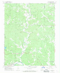
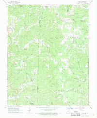
1968 Map of Williford
USGS Topo · Published 1969About this map
The Spring River corridor defines the southern reaches of this Sharp County landscape, where the St Louis - San Francisco railroad follows the river's bend past Williford. This 1960s survey documents a region of rugged relief and deep drainage patterns, including Martins Creek, Happy Hollow, and Deadman Hollow. The emergence of modern recreational development is visible at Ozark Acres and Vagabond Lake, contrasting with the established rural character of the uplands. Genealogists will find a high density of family and community burial grounds, such as Groves Cem, Kellett Cem, and Ratliff Cem, often situated near small country churches like Bradford Chapel. Natural landmarks including Morris Cave and various family-named features like Levi Hill and Ellison Hill provide a clear view of the area's local history and topography before further modern expansion.
Find a feature on this map
62 named features on this map. Tap any name to fly to it.
Don’t see what you’re looking for? This feature index may not catch every label — zoom into the map to look around manually.
Map Details
Editions of this 1968 Williford Map
2 editions found
Other maps of this area

1934 · Powhatan
USGS Topo · 1:62,500

1935 · Powhatan
USGS Topo · 1:62,500

1957 · Poplar Bluff
USGS Topo · 1:250,000

1959 · Poplar Bluff
USGS Topo · 1:250,000

1960 · Poplar Bluff
USGS Topo · 1:250,000

1966 · Ravenden Springs
USGS Topo · 1:24,000
1966 · Imboden
USGS Topo · 1:24,000

1968 · Hardy
USGS Topo · 1:24,000
1968 · Hardy NE
USGS Topo · 1:24,000
1968 · Wirth
USGS Topo · 1:24,000