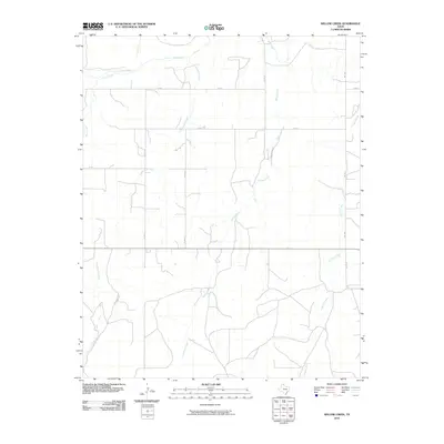
2010 Map of Willow Creek
USGS Topo · Published 2010About this map
Wolf Creek and its many tributaries, including Cottonwood Creek and Plum Creek, dominate this section of the Texas Panhandle near the turn of the 21st century. The landscape is defined by the dendritic drainage patterns typical of the region, where seasonal waterways have etched deep channels into the plains. Large ranching tracts are evident through named corridors like Tyson Ranch Rd and Kirk Ranch Rd, illustrating the persistence of large-scale cattle operations in Lipscomb County. The road network follows a strict sectional grid, with routes such as Co Rd T and Co Rd U cutting across the terrain, occasionally interrupted by the winding path of Willow Creek. This survey provides a clear look at the rural infrastructure and hydraulic geography of the area, anchored by Fm 1454 on the eastern edge.
Find a feature on this map
16 named features on this map. Tap any name to fly to it.
Don’t see what you’re looking for? This feature index may not catch every label — zoom into the map to look around manually.
Map Details
Editions of this 2010 Willow Creek Map
This is the sole edition of this map. No revisions or reprints were ever made.
Other maps of this area

1954 · Perryton
USGS Topo · 1:250,000

1958 · Perryton
USGS Topo · 1:250,000

1972 · Follett SE
USGS Topo · 1:24,000

1972 · Dugout Creek
USGS Topo · 1:24,000

1972 · Skunk Creek
USGS Topo · 1:24,000
1972 · Higgins North
USGS Topo · 1:24,000

1972 · Glazier
USGS Topo · 1:24,000

1972 · Willow Creek
USGS Topo · 1:24,000
1972 · Higgins South
USGS Topo · 1:24,000

1972 · Lipscomb
USGS Topo · 1:24,000