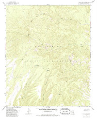
1967 Map of Willow Mtn.
USGS Topo · Published 1986About this map
The San Carlos Indian Reservation land dominates this high-altitude landscape in Graham County, characterized by a complex network of canyons and seasonal water sources. The peak of Willow Mtn stands as a primary landmark, topped by a Lookout that once surveyed the surrounding timber and drainages. The naming of features like Windy Bob Canyon and the associated Windy Bob Tank suggests a history of local ranching or personal nomenclature, while other stock-watering sites like Packsaddle Tank and Jimmy Loya Tank underscore the area's use for livestock management.
Find a feature on this map
14 named features on this map. Tap any name to fly to it.
Don’t see what you’re looking for? This feature index may not catch every label — zoom into the map to look around manually.
Map Details
Editions of this 1967 Willow Mtn. Map
2 editions found
Other maps of this area

1913 · Morenci
USGS Topo · 1:125,000

1915 · Morenci
USGS Topo · 1:125,000

1922 · Nutrioso
USGS Topo · 1:125,000

1954 · Clifton
USGS Topo · 1:250,000

1957 · Clifton
USGS Topo · 1:250,000

1958 · Clifton
USGS Topo · 1:250,000

1958 · Hannagan Meadow
USGS Topo · 1:62,500

1962 · Clifton
USGS Topo · 1:250,000

1967 · Freezeout Mountain
USGS Topo · 1:24,000

1967 · Robinson Mesa
USGS Topo · 1:24,000