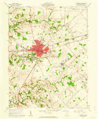
1961 Map of Wilmington
USGS Topo · Published 1962About this map
Wilmington serves as the central hub of this early 1960s landscape, where the campus of Wilmington College and the local Courthouse anchor a community defined by its intersection of rail and air transport. The Baltimore and Ohio and Pennsylvania railroads bisect the town, while the massive footprint of the Clinton County Air Force Base dominates the southeast, complete with its Base Chapel and specialized Control Tower. Beyond the urban core, the terrain is shaped by Todd Fork and Lytle Creek, with the southern edge of the map showing the developed recreation area at Cowan State Park. Smaller outlying communities like Starbucktown and Burtonville illustrate the persistent rural settlement patterns of Union and Washington townships. The map records various local institutions, from the County Childrens Home and Memorial Hospital to numerous neighborhood schools like Denver Place Sch and the Senior High Sch.
Find a feature on this map
74 named features on this map. Tap any name to fly to it.
Don’t see what you’re looking for? This feature index may not catch every label — zoom into the map to look around manually.
Map Details
Editions of this 1961 Wilmington Map
4 editions found
Other maps of this area

1907 · Blanchester
USGS Topo · 1:62,500

1916 · Octa
USGS Topo · 1:62,500

1917 · Xenia
USGS Topo · 1:62,500

1917 · Sabina
USGS Topo · 1:62,500

1943 · Sabina
USGS Topo · 1:62,500

1944 · Octa
USGS Topo · 1:62,500

1947 · Columbus
USGS Topo · 1:250,000

1955 · New Burlington
USGS Topo · 1:24,000

1955 · Port William
USGS Topo · 1:24,000

1960 · Martinsville
USGS Topo · 1:24,000