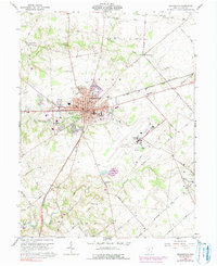
1961 Map of Wilmington
USGS Topo · Published 1991About this map
Wilmington College and the central courthouse define the core of this Clinton County seat during a period of mid-century growth. The map illustrates the convergence of the Baltimore and Ohio and Penn Central railroads, which shaped the city's industrial layout near Townsend Field. To the south, the expansion of the Wilmington Industrial Airpark reflects the transition of former agricultural land into a specialized transportation hub, while Cowan State Park and Cowan Lake anchor the southwestern corner of the quadrangle. Outside the city limits, a dense network of country roads such as Starbuck Road and Denver Road connects long-established rural points like Starbucktown and Burtonville. Genealogists will find several burial sites including Sugar Grove Cemetery and New Antioch Cem, alongside vanished school locations like New Antioch Sch.
Find a feature on this map
81 named features on this map. Tap any name to fly to it.
Don’t see what you’re looking for? This feature index may not catch every label — zoom into the map to look around manually.
Map Details
Editions of this 1961 Wilmington Map
4 editions found
Other maps of this area

1907 · Blanchester
USGS Topo · 1:62,500

1916 · Octa
USGS Topo · 1:62,500

1917 · Xenia
USGS Topo · 1:62,500

1917 · Sabina
USGS Topo · 1:62,500

1943 · Sabina
USGS Topo · 1:62,500

1944 · Octa
USGS Topo · 1:62,500

1947 · Columbus
USGS Topo · 1:250,000

1955 · New Burlington
USGS Topo · 1:24,000

1955 · Port William
USGS Topo · 1:24,000

1960 · Martinsville
USGS Topo · 1:24,000