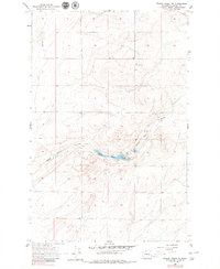
1956 Map of Wilson Creek SE
USGS Topo · Published 1979About this map
Black Rock Coulee carves through this portion of Grant County, anchoring a landscape shaped by ancient geological forces and sparse high-desert settlement. Based on surveys by the USBR in 1937 and aerial photography from 1954, the map reveals a remote section of Washington where water remains the primary driver of human geography. The presence of Spring and Well points to the necessity of finding reliable water sources in this arid region, while the small settlement of Marlin appears in the northeast corner at the boundary of the coulee. The central feature, Black Rock Lake, sits deep within the coulee floor, surrounded by the intricate contouring of the surrounding plateau. The inclusion of the Marlin Azimuth station highlights the technical surveying work required to chart this expansive, open terrain during the mid-twentieth century.
Find a feature on this map
9 named features on this map. Tap any name to fly to it.
Don’t see what you’re looking for? This feature index may not catch every label — zoom into the map to look around manually.
Map Details
Editions of this 1956 Wilson Creek SE Map
2 editions found
Other maps of this area

1923 · Wheeler
USGS Topo · 1:62,500

1925 · Wheeler
USGS Topo · 1:62,500

1925 · Schrag
USGS Topo · 1:62,500

1953 · Ritzville
USGS Topo · 1:250,000

1956 · Wheeler
USGS Topo · 1:24,000

1956 · Wilson Creek SW
USGS Topo · 1:24,000

1956 · Wheeler NE
USGS Topo · 1:24,000

1956 · Wilson Creek SE
USGS Topo · 1:24,000

1956 · Wilson Creek NW
USGS Topo · 1:24,000

1956 · Wilson Creek
USGS Topo · 1:62,500