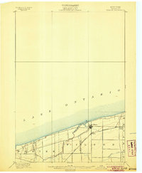
1900 Map of Wilson
USGS Topo · Published 1906About this map
The Niagara County shoreline of Lake Ontario defines the northern edge of this 1893 survey, showing a landscape shaped by drainage and rail development. The village of Wilson serves as the primary hub, situated where Twelvemile Creek meets the lake. Local transportation is anchored by the Rome Watertown and Station railroad, which runs parallel to the coast, connecting the lakeside community with Ogdensburg and North Wilson to the east.
Find a feature on this map
11 named features on this map. Tap any name to fly to it.
Don’t see what you’re looking for? This feature index may not catch every label — zoom into the map to look around manually.
Map Details
Editions of this 1900 Wilson Map
5 editions found
Other maps of this area

1894 · Niagara Falls
USGS Topo · 1:62,500

1894 · Wilson
USGS Topo · 1:62,500

1896 · Niagara Falls
USGS Topo · 1:62,500

1897 · Tonawanda
USGS Topo · 1:62,500

1897 · Olcott
USGS Topo · 1:62,500

1897 · Lockport
USGS Topo · 1:62,500

1899 · Niagara
USGS Topo · 1:125,000

1900 · Wilson
USGS Topo · 1:62,500

1900 · Tonawanda
USGS Topo · 1:62,500

1900 · Niagara Falls
USGS Topo · 1:62,500