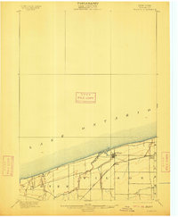
1900 Map of Wilson
USGS Topo · Published 1912About this map
Lake Ontario defines the northern edge of this Niagara County landscape, where the shoreline meets a network of fruit-growing country and small hamlets at the turn of the century. The village of Wilson serves as the primary hub, situated where Twelvemile Creek flows into the lake. Inland, the arrival of the Rome Watertown and Ogdensburg Railroad reshaped the local economy, connecting Wilson Station to broader markets. The terrain is marked by the steady paths of Steins Creek and Hopkins Creek, which drain the agricultural lands of Porter, Wilson, and Newfane townships. This survey, conducted under the direction of George Otis Smith, captures the settlement patterns of North Wilson and the surrounding farmsteads before the modern expansion of the lakefront, offering a look at the rural infrastructure of the era.
Find a feature on this map
12 named features on this map. Tap any name to fly to it.
Don’t see what you’re looking for? This feature index may not catch every label — zoom into the map to look around manually.
Map Details
Editions of this 1900 Wilson Map
5 editions found
Other maps of this area

1894 · Niagara Falls
USGS Topo · 1:62,500

1894 · Wilson
USGS Topo · 1:62,500

1896 · Niagara Falls
USGS Topo · 1:62,500

1897 · Tonawanda
USGS Topo · 1:62,500

1897 · Olcott
USGS Topo · 1:62,500

1897 · Lockport
USGS Topo · 1:62,500

1899 · Niagara
USGS Topo · 1:125,000

1900 · Wilson
USGS Topo · 1:62,500

1900 · Tonawanda
USGS Topo · 1:62,500

1900 · Niagara Falls
USGS Topo · 1:62,500