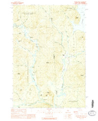
1989 Map of Wilsons Mills
USGS Topo · Published 1989About this map
Wilsons Mills serves as a focal point in this northern wilderness, situated where the Magalloway River meets the border of Maine and New Hampshire. The landscape is defined by massive land tracts, including the Atkinson and Gilmanton Academy Grant and the Second College Grant, reflecting the region's history of private educational endowments through timberland. These large blocks of territory are intersected by the winding Dead Diamond River and Swift Diamond River, which flow through valleys like Loomis Valley toward their eventual confluence.
Find a feature on this map
53 named features on this map. Tap any name to fly to it.
Don’t see what you’re looking for? This feature index may not catch every label — zoom into the map to look around manually.
Map Details
Editions of this 1989 Wilsons Mills Map
2 editions found
Other maps of this area

1927 · Second Lake
USGS Topo · 1:62,500

1930 · Errol
USGS Topo · 1:62,500

1931 · Cupsuptic
USGS Topo · 1:48,000

1932 · Second Lake
USGS Topo · 1:62,500

1934 · Cupsuptic
USGS Topo · 1:62,500

1934 · Errol
USGS Topo · 1:62,500

1935 · Cupsuptic
USGS Topo · 1:62,500

1940 · Oquossoc
USGS Topo · 1:62,500

1942 · Oquossoc
USGS Topo · 1:62,500

1949 · Jackman
USGS Topo · 1:250,000
Featured Places
- Magalloway Plantation, ME
- Lincoln Plantation, ME
- Atkinson and Gilmanton Academy Grant, NH
- Second College Grant, NH
- Wilsons Mills, Lincoln Plantation