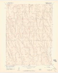
1958 Map of Wilsonville NE
USGS Topo · Published 1959About this map
The rolling hills of Furnas County in the late 1950s are defined by the sharp incisions of local drainages and the rigid lines of township boundaries. In the northern section, Wild Horse Canyon carves a deep path through the landscape, while Timmons Creek drains the eastern territory. These natural features contrast with the straight administrative lines of Logan Vincent and Wilsonville Lynden, reflecting the grid-based settlement patterns of the Nebraska prairie. Mapped as part of the Missouri River Basin development program, this survey captures the rural layout of the region just before modern agricultural shifts transformed the traditional sectional boundaries and unimproved road networks of the mid-century period.
Find a feature on this map
4 named features on this map. Tap any name to fly to it.
Don’t see what you’re looking for? This feature index may not catch every label — zoom into the map to look around manually.
Map Details
Editions of this 1958 Wilsonville NE Map
2 editions found
Other maps of this area

1896 · Arapahoe
USGS Topo · 1:125,000

1898 · Arapahoe
USGS Topo · 1:125,000

1954 · McCook
USGS Topo · 1:250,000

1955 · Grand Island
USGS Topo · 1:250,000

1956 · Cambridge
USGS Topo · 1:24,000

1957 · McCook
USGS Topo · 1:250,000

1957 · Grand Island
USGS Topo · 1:250,000
1957 · Beaver City SW
USGS Topo · 1:24,000

1957 · Shippee
USGS Topo · 1:24,000
1957 · Wilsonville
USGS Topo · 1:24,000