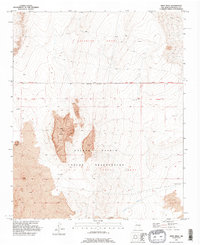
1991 Map of Wind Mesa
USGS Topo · Published 1996About this map
Isleta Pueblo Indian Reservation lands dominate this high-desert landscape south of Albuquerque, defined by extensive volcanic features. The prominent Wind Mesa and nearby Blackbird Hill are capped with deposits of Lava, reflecting the geological character of the Rio Grande rift. This 1991 revision shows a topography carved by drainage systems like Cedar Wash, which cuts across the southeastern portion of the Pueblo of Isleta Grant. To the north, the boundary with the Pajarito Grant is clearly delineated, marking historical land divisions that persist into the modern era. Isolated Windmills are scattered across the terrain, indicating the ongoing reliance on groundwater in this arid environment near Sandy Point.
Find a feature on this map
11 named features on this map. Tap any name to fly to it.
Don’t see what you’re looking for? This feature index may not catch every label — zoom into the map to look around manually.
Map Details
Editions of this 1991 Wind Mesa Map
This is the sole edition of this map. No revisions or reprints were ever made.
Other maps of this area

1888 · Bernalillo
USGS Topo · 1:125,000

1889 · Albuquerque
USGS Topo · 1:125,000

1893 · Albuquerque
USGS Topo · 1:125,000

1934 · West Albuquerque
USGS Topo · 1:24,000

1938 · Albuquerque
USGS Topo · 1:62,500

1952 · Wind Mesa
USGS Topo · 1:24,000

1952 · Dalies
USGS Topo · 1:24,000

1952 · Rio Puerco
USGS Topo · 1:24,000

1952 · Los Lunas
USGS Topo · 1:24,000

1952 · Isleta
USGS Topo · 1:24,000