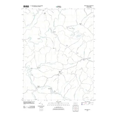
2010 Map of Wind Ridge
USGS Topo · Published 2010About this map
Wind Ridge and the surrounding townships in 2010 exhibit a landscape defined by deeply carved stream valleys and ridge-top settlements. The road network follows these high points, connecting communities like Nebo, Crabapple, and Graysville. In the southern portion of the sheet, the North Fork Dunkard Fork and South Fork Dunkard Fork converge near Ryerson Station, where the Ryerson Station State Park Dam forms a central geographical point. This area is characterized by a significant number of family and community burial grounds, including Zollars Cemetery, Chapel Cemetery, and Braddock Cemetery, providing essential data for genealogical research. The presence of the Jacktown Fairgrounds near Wind Ridge and the Four Seasons Campground suggests the enduring role of local recreation and agriculture in this corner of Pennsylvania. Small, isolated locales like Simpson Store and Burdette reflect the dispersed rural settlement pattern that has persisted along the Pennsylvania-West Virginia border.
Find a feature on this map
108 named features on this map. Tap any name to fly to it.
Don’t see what you’re looking for? This feature index may not catch every label — zoom into the map to look around manually.
Map Details
Editions of this 2010 Wind Ridge Map
This is the sole edition of this map. No revisions or reprints were ever made.
Other maps of this area

1902 · Wheeling
USGS Topo · 1:62,500

1904 · Cameron
USGS Topo · 1:62,500

1905 · Rogersville
USGS Topo · 1:62,500

1907 · Claysville
USGS Topo · 1:62,500

1935 · Cameron
USGS Topo · 1:62,500

1935 · Wheeling
USGS Topo · 1:62,500

1942 · Cameron
USGS Topo · 1:62,500

1942 · Wheeling
USGS Topo · 1:62,500

1949 · Clarksburg
USGS Topo · 1:250,000

1951 · Canton
USGS Topo · 1:250,000
Featured Places
- East Finley Township, PA
- West Finley Township, PA
- Enon, East Finley Township
- Richhill Township, PA
- Bryan, PA