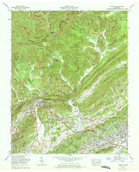
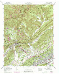
1968 Map of Windrock
USGS Topo · Published 1972About this map
Windrock Mountain and Buffalo Mountain dominate the northern landscape of this 1968 survey, where the heavy industry of the Cumberland Mountains is visible through numerous strip mines scarring the ridges. The settlement of Oliver Springs sits at the junction of Walden Ridge and the Southern railroad line, serving as a hub for the surrounding mining communities of Upper Windrock and Tupper Town. To the south, the early footprint of Oak Ridge begins to take shape, featuring the Atomic Energy Museum and the Oak Ridge Airpark. The map preserves a dense network of family-named landmarks and cemeteries, such as Hoskins Cem and Allen Cem, alongside rural institutions like Big Mountain Church and Indian Creek Ch. This record captures a region in transition, balancing its deep-rooted coal mining heritage with the emerging scientific and residential growth of the post-war era.
Find a feature on this map
99 named features on this map. Tap any name to fly to it.
Don’t see what you’re looking for? This feature index may not catch every label — zoom into the map to look around manually.
Map Details
Editions of this 1968 Windrock Map
5 editions found
Other maps of this area

1893 · Briceville
USGS Topo · 1:125,000

1895 · Loudon
USGS Topo · 1:125,000

1895 · Briceville
USGS Topo · 1:125,000

1896 · Briceville
USGS Topo · 1:125,000

1935 · Elverton
USGS Topo · 1:24,000

1935 · Bethel Valley
USGS Topo · 1:24,000

1935 · Lovell
USGS Topo · 1:24,000

1936 · Hogbell Gap
USGS Topo · 1:24,000

1936 · Duncan Flats
USGS Topo · 1:24,000

1936 · Windrock
USGS Topo · 1:24,000