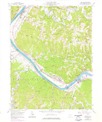
1958 Map of Winfield
USGS Topo · Published 1976About this map
The Kanawha River serves as the central artery for this portion of Putnam County, driving the settlement patterns and industrial infrastructure of the mid-20th century. Major riverside hubs include Winfield, the county seat, and Buffalo, where the Conrail line parallels the water to support regional transit. The map documents the vital Winfield Lock Dam No 1 Gaging Sta, a critical piece of river navigation infrastructure during this era.
Find a feature on this map
57 named features on this map. Tap any name to fly to it.
Don’t see what you’re looking for? This feature index may not catch every label — zoom into the map to look around manually.
Map Details
Editions of this 1958 Winfield Map
3 editions found
Other maps of this area

1892 · Huntington
USGS Topo · 1:125,000

1898 · Huntington
USGS Topo · 1:125,000

1899 · Charleston
USGS Topo · 1:125,000

1902 · Milton
USGS Topo · 1:62,500

1906 · Glenwood
USGS Topo · 1:62,500

1906 · Winfield
USGS Topo · 1:62,500

1908 · Glenwood
USGS Topo · 1:62,500

1908 · Winfield
USGS Topo · 1:62,500

1909 · Saint Albans
USGS Topo · 1:62,500

1931 · Saint Albans
USGS Topo · 1:62,500