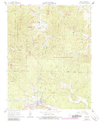
1965 Map of Winona
USGS Topo · Published 1985About this map
Winona serves as the primary hub in this Missouri Ozarks landscape, where timber and terrain have long shaped the local economy. The town is flanked by the massive reaches of Rocky Creek State Forest and Mark Twain National Forest, reflecting the region’s mid-century focus on public forest management. For those interested in the industrial history of Shannon County, the Sutton Mine is located north of town along Sutton Hollow, while the surrounding hills are carved by numerous named drainages like Blackroot Hollow and Nash Hollow.
Find a feature on this map
43 named features on this map. Tap any name to fly to it.
Don’t see what you’re looking for? This feature index may not catch every label — zoom into the map to look around manually.
Map Details
Editions of this 1965 Winona Map
3 editions found
Other maps of this area

1915 · Eminence
USGS Topo · 1:62,500

1917 · Eminence
USGS Topo · 1:62,500

1928 · Cardareva
USGS Topo · 1:62,500

1931 · Bandyville
USGS Topo · 1:48,000

1944 · Van Buren
USGS Topo · 1:62,500

1944 · Birch Tree
USGS Topo · 1:62,500

1946 · Van Buren
USGS Topo · 1:62,500

1948 · Birch Tree
USGS Topo · 1:62,500

1949 · Rolla
USGS Topo · 1:250,000

1949 · Cardareva
USGS Topo · 1:62,500