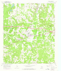
1966 Map of Winona
USGS Topo · Published 1975About this map
St Louis Southwestern rail lines and the winding waters of Harris Creek define this section of Smith County during the mid-1960s and early 1970s. The landscape is dotted with rural landmarks that speak to the area's social and health history, most notably the East Texas Tuberculosis Hospital located south of the Dragstrip. Smaller communities like Owentown, Wiggins, and Starrville are anchored by numerous country churches and family burial grounds, including St Viola Ch and the McDougle Cem.
Find a feature on this map
45 named features on this map. Tap any name to fly to it.
Don’t see what you’re looking for? This feature index may not catch every label — zoom into the map to look around manually.
Map Details
Editions of this 1966 Winona Map
2 editions found
Other maps of this area

1938 · Winona
USGS Topo · 1:48,000

1943 · Winona
USGS Topo · 1:62,500

1948 · Tyler
USGS Topo · 1:62,500

1949 · Tyler
USGS Topo · 1:62,500

1956 · Tyler
USGS Topo · 1:250,000

1960 · Hawkins
USGS Topo · 1:24,000

1960 · Big Sandy
USGS Topo · 1:24,000

1960 · Crow
USGS Topo · 1:24,000

1966 · Hope Pond
USGS Topo · 1:24,000
1966 · Starrville
USGS Topo · 1:24,000