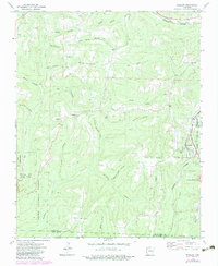
1973 Map of Winslow
USGS Topo · Published 1983About this map
Winslow serves as a prominent landmark on the eastern edge of this Ozark survey, where the Burlington Northern railroad winds through the terrain alongside the West Fork White River. The landscape is deeply incised by dozens of hollows, including Honey Hollow, Rose Hollow, and Wattle Hollow, which dictate the placement of early settlements and roads. Small rural communities and homesteads like Blackburn, Boston, and Banyard are scattered throughout the region, often centered around local institutions such as Bethlehem Ch and Oak Grove Ch.
Find a feature on this map
46 named features on this map. Tap any name to fly to it.
Don’t see what you’re looking for? This feature index may not catch every label — zoom into the map to look around manually.
Map Details
Editions of this 1973 Winslow Map
3 editions found
Other maps of this area

1898 · Winslow #4
USGS Topo · 1:62,500

1898 · Winslow #3
USGS Topo · 1:62,500

1898 · Winslow
USGS Topo · 1:125,000

1901 · Winslow
USGS Topo · 1:125,000

1946 · Fort Smith
USGS Topo · 1:250,000

1965 · Fort Smith
USGS Topo · 1:250,000

1967 · Fort Smith
USGS Topo · 1:250,000
1969 · Fern
USGS Topo · 1:24,000
1969 · Mountainburg
USGS Topo · 1:24,000
1970 · Rudy NE
USGS Topo · 1:24,000