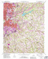
1950 Map of Winston-Salem East
USGS Topo · Published 1994About this map
Winston-Salem's eastern reaches show a dynamic mid-century transition from dense urban street grids to the rural landscapes of the Forsyth and Davidson county line. The map captures the growth of Winston-Salem State University and the prominent Bowman Gray Stadium alongside established neighborhoods like Columbia Heights and Waughtown. Institutional foundations are visible through the grounds of Salem College and the sprawling Salem Cem, while industry and infrastructure are anchored by the Filtration Plant and Piedmont Quarry.
Find a feature on this map
66 named features on this map. Tap any name to fly to it.
Don’t see what you’re looking for? This feature index may not catch every label — zoom into the map to look around manually.
Map Details
Editions of this 1950 Winston-Salem East Map
5 editions found
Other maps of this area

1949 · Eller
USGS Topo · 1:24,000

1949 · High Point West
USGS Topo · 1:24,000

1950 · Winston-Salem West
USGS Topo · 1:24,000

1950 · Winston-Salem East
USGS Topo · 1:24,000

1951 · Winston-Salem West
USGS Topo · 1:24,000

1951 · Winston-Salem East
USGS Topo · 1:24,000

1951 · Rural Hall
USGS Topo · 1:24,000

1951 · Walkertown
USGS Topo · 1:24,000

1953 · Charlotte
USGS Topo · 1:250,000

1953 · Winston-Salem
USGS Topo · 1:250,000