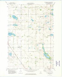
1973 Map of Wintermute Lake
USGS Topo · Published 1975About this map
The glacial wetlands of Stevens County dominate this early 1970s survey, characterized by a complex network of marshes and open water. The landscape is defined by the eponymous Wintermute Lake and the winding course of Twelvemile Creek, which flows through a region heavily dedicated to conservation. Multiple tracts of the National Waterfowl Production Area and the Klason State Wildlife Management Area illustrate the intersection of agricultural land and protected habitat. Infrastructure is concentrated along the western corridor, where the Burlington Northern railroad cuts through the prairie, passing just east of the Donnelly Corporate Boundary. This period represents a snapshot of the rural townships of Rendsville and Morris before more modern drainage and development altered the local hydrology.
Find a feature on this map
14 named features on this map. Tap any name to fly to it.
Don’t see what you’re looking for? This feature index may not catch every label — zoom into the map to look around manually.
Map Details
Editions of this 1973 Wintermute Lake Map
This is the sole edition of this map. No revisions or reprints were ever made.
Other maps of this area

1910 · Chokio
USGS Topo · 1:62,500

1911 · Barrett
USGS Topo · 1:62,500

1911 · Herman
USGS Topo · 1:62,500

1912 · Chokio
USGS Topo · 1:62,500

1912 · Morris
USGS Topo · 1:62,500

1953 · Milbank
USGS Topo · 1:250,000

1953 · Saint Cloud
USGS Topo · 1:250,000

1957 · Saint Cloud
USGS Topo · 1:250,000

1958 · Milbank
USGS Topo · 1:250,000

1958 · Saint Cloud
USGS Topo · 1:250,000