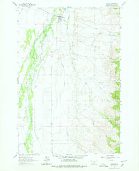
1962 Map of Wisdom
USGS Topo · Published 1978About this map
Wisdom serves as the focal point of this high-altitude valley, situated near the winding course of the Big Hole River. The map illustrates a rural landscape defined by extensive water systems, including Steel Creek, Stanley Creek, and Francis Creek, which feed into the main river channel. This 1962 field check captures the area’s ranching and resource-based character before significant modern development, showing the proximity of the Beaverhead National Forest to the east.
Find a feature on this map
19 named features on this map. Tap any name to fly to it.
Don’t see what you’re looking for? This feature index may not catch every label — zoom into the map to look around manually.
Map Details
Editions of this 1962 Wisdom Map
2 editions found
Other maps of this area

1955 · Dillon
USGS Topo · 1:250,000

1957 · Dillon
USGS Topo · 1:250,000

1958 · Dillon
USGS Topo · 1:250,000

1962 · Dillon
USGS Topo · 1:250,000

1962 · Wisdom
USGS Topo · 1:24,000

1962 · Mud Lake
USGS Topo · 1:24,000

1962 · Stewart Mountain
USGS Topo · 1:24,000

1962 · Proposal Rock
USGS Topo · 1:24,000

1965 · Dillon
USGS Topo · 1:250,000

1966 · Gibbons School
USGS Topo · 1:24,000