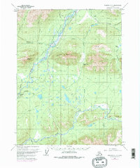
1970 Map of Wiseman A-1
USGS Topo · Published 1977About this map
The Trans-Alaska Pipeline is documented here during its critical construction phase in the mid-1970s, carving a path through the Brooks Range foothills. The landscape is dominated by the massive drainage systems of the Middle Fork Koyukuk River and the South Fork Koyukuk River, which converge amid a complex network of marshes and gravel bars. The presence of Tramway Bar and various remote cabins along the water suggest the area's history of river-based travel and subsistence. High-altitude landmarks like Cathedral Mountain and Twelvemile Mountain flank the river valleys, while established routes such as the Winter Trail and Sitkum Pass indicate the seasonal movement patterns required in this subarctic environment before the pipeline's infrastructure began to transform the region's accessibility.
Find a feature on this map
33 named features on this map. Tap any name to fly to it.
Don’t see what you’re looking for? This feature index may not catch every label — zoom into the map to look around manually.
Map Details
Editions of this 1970 Wiseman A-1 Map
4 editions found

Other maps of this area

1951 · Bettles
USGS Topo · 1:250,000

1951 · Chandalar
USGS Topo · 1:250,000

1951 · Beaver
USGS Topo · 1:250,000

1951 · Wiseman
USGS Topo · 1:250,000

1956 · Chandalar
USGS Topo · 1:250,000

1956 · Bettles
USGS Topo · 1:250,000

1956 · Wiseman
USGS Topo · 1:250,000

1956 · Beaver
USGS Topo · 1:250,000

1964 · Wiseman
USGS Topo · 1:250,000

1964 · Chandalar
USGS Topo · 1:250,000