
1970 Map of Wiseman A-2
USGS Topo · Published 1973About this map
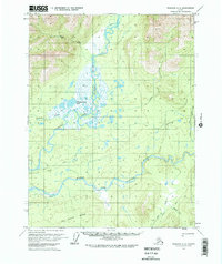
The confluence of the Koyukuk River North Fork and its surrounding wetlands dominates this 1970 interior Alaska landscape. The topography transitions from the low-lying basins of Florence Creek Lake to the rising elevations of the Jack White Range in the south. This survey reveals a sparse network of human presence, primarily indicated by a Winter Trail cutting across the eastern sector and isolated structures like a Cabin near the river bend. The intricate drainage patterns of Alder Creek, Winnie Creek, and Mailbox Creek highlight the seasonal hydrology of the Yukon-Koyukuk region. A notable geological feature, a Pingo, is identified in the southeast, indicating periglacial activity characteristic of this subarctic environment. The lack of established roads and the reliance on seasonal trails underscore the isolation and specialized transportation requirements of the Brooks Range foothills during this era.
Find a feature on this map
14 named features on this map. Tap any name to fly to it.
Don’t see what you’re looking for? This feature index may not catch every label — zoom into the map to look around manually.
Map Details
Editions of this 1970 Wiseman A-2 Map
2 editions found
Other maps of this area

1951 · Bettles
USGS Topo · 1:250,000

1951 · Wiseman
USGS Topo · 1:250,000

1956 · Bettles
USGS Topo · 1:250,000

1956 · Wiseman
USGS Topo · 1:250,000

1964 · Wiseman
USGS Topo · 1:250,000

1970 · Wiseman A-1
USGS Topo · 1:63,360
1970 · Bettles D-1
USGS Topo · 1:63,360

1970 · Wiseman A-3
USGS Topo · 1:63,360

1970 · Bettles D-3
USGS Topo · 1:63,360

1970 · Bettles D-2
USGS Topo · 1:63,360