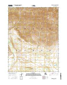
2016 Map of Wiseman A-4 NE
USGS Topo · Published 2016About this map
Death Valley dominates the southwestern portion of this Alaskan interior landscape, a low-lying contrast to the prominent Gilroy Mtn that rises in the northeast. This terrain is defined by a remote drainage network where glacial or snowmelt streams like Suckik Cr and Gilroy Cr carve through the high country. The absence of permanent settlements or infrastructure reflects the wilderness character of the Yukon-Koyukuk region in the early twenty-first century, with the landscape organized strictly by the Public Land Survey System, including t28n r19w and surrounding townships. For the researcher or hydrologist, the map provides a precise record of drainage patterns through Timber Cr and the topographical shifts surrounding the central peaks, showing a land untouched by road networks or industrial development.
Find a feature on this map
9 named features on this map. Tap any name to fly to it.
Don’t see what you’re looking for? This feature index may not catch every label — zoom into the map to look around manually.
Map Details
Editions of this 2016 Wiseman A-4 NE Map
This is the sole edition of this map. No revisions or reprints were ever made.
Other maps of this area

1951 · Wiseman
USGS Topo · 1:250,000

1956 · Wiseman
USGS Topo · 1:250,000

1964 · Wiseman
USGS Topo · 1:250,000

1970 · Wiseman A-4
USGS Topo · 1:63,360

1970 · Wiseman A-3
USGS Topo · 1:63,360
1971 · Wiseman B-3
USGS Topo · 1:63,360
1971 · Wiseman B-4
USGS Topo · 1:63,360
2016 · Wiseman A-3 NW
USGS Topo · 1:25,000
2016 · Wiseman B-4 SE
USGS Topo · 1:25,000
2016 · Wiseman B-4 SW
USGS Topo · 1:25,000