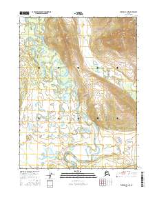
2016 Map of Wiseman A-4 NW
USGS Topo · Published 2016About this map
The John River snakes through the center of this Interior Alaska landscape, creating a wide floodplain of oxbow lakes and braided channels. This 2016 survey captures the remote wilderness where the river valley is hemmed in by prominent peaks like Threetime Mtn to the north and Button Mtn to the southeast. The drainage network is complex, fed by tributaries including Missouri Cr and Timber Cr, which carve through the high ground. The lack of roads or established settlements emphasizes the pristine character of the Yukon-Koyukuk region, where the primary landmarks are the massive topographic rises and the shifting course of the glacial-fed river system. This map is a primary resource for understanding the hydrology of the Brooks Range foothills, showing how Suckik Cr and other small streams feed into the larger river basin.
Find a feature on this map
10 named features on this map. Tap any name to fly to it.
Don’t see what you’re looking for? This feature index may not catch every label — zoom into the map to look around manually.
Map Details
Editions of this 2016 Wiseman A-4 NW Map
This is the sole edition of this map. No revisions or reprints were ever made.
Other maps of this area

1951 · Wiseman
USGS Topo · 1:250,000

1956 · Wiseman
USGS Topo · 1:250,000

1964 · Wiseman
USGS Topo · 1:250,000

1970 · Wiseman A-4
USGS Topo · 1:63,360

1970 · Wiseman A-5
USGS Topo · 1:63,360
1971 · Wiseman B-5
USGS Topo · 1:63,360
1971 · Wiseman B-4
USGS Topo · 1:63,360
2016 · Wiseman B-4 SE
USGS Topo · 1:25,000
2016 · Wiseman B-4 SW
USGS Topo · 1:25,000
2016 · Wiseman A-5 SE
USGS Topo · 1:25,000