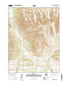
2016 Map of Wiseman A-6 NE
USGS Topo · Published 2016About this map
Mettenpherg Creek winds through this interior Alaskan wilderness, cutting through the varied terrain of the Yukon-Koyukuk region. The landscape is defined by its dramatic elevation changes, with ridges reaching over 4,000 feet. These steep slopes feed into the drainage systems of Mettenpherg Cr and Jones Cr, creating a complex network of seasonal and permanent watercourses. The lack of named settlements or roads reflects the isolation of this territory, where the primary human footprint is found in the Public Land Survey System grids, such as t28n r23w and t27n r24w. This 2016 survey illustrates the undeveloped character of the Brooks Range foothills, providing a clear view of the natural hydrology and topography before any significant modern encroachment.
Find a feature on this map
7 named features on this map. Tap any name to fly to it.
Don’t see what you’re looking for? This feature index may not catch every label — zoom into the map to look around manually.
Map Details
Editions of this 2016 Wiseman A-6 NE Map
This is the sole edition of this map. No revisions or reprints were ever made.
Other maps of this area

1951 · Wiseman
USGS Topo · 1:250,000

1956 · Wiseman
USGS Topo · 1:250,000

1964 · Wiseman
USGS Topo · 1:250,000
1970 · Wiseman A-6
USGS Topo · 1:63,360

1970 · Wiseman A-5
USGS Topo · 1:63,360
1971 · Wiseman B-5
USGS Topo · 1:63,360
1986 · Wiseman B-6
USGS Topo · 1:63,360
2016 · Wiseman B-5 SW
USGS Topo · 1:25,000
2016 · Wiseman A-5 SW
USGS Topo · 1:25,000
2016 · Wiseman A-6 SE
USGS Topo · 1:25,000