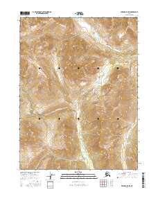
2016 Map of Wiseman B-5 SW
USGS Topo · Published 2016About this map
Malamute Fork flows through this interior Alaskan landscape, defining the drainage patterns of a region marked by significant elevation changes and deep valleys. The intricate contour work of the U.S. Geological Survey details the high ridges and steep slopes that characterize the Brooks Range foothills. Waterways such as Sixtymile Cr in the northern sections and Midas Cr in the southeast provide the primary geographic structure for this wilderness area. The map illustrates a strictly natural environment, where the absence of roads or permanent settlements emphasizes the isolation of the Yukon-Koyukuk region. This 2016 survey is an essential reference for understanding the hydrological network and topography of the remote drainage systems within the Koyukuk River watershed.
Find a feature on this map
7 named features on this map. Tap any name to fly to it.
Don’t see what you’re looking for? This feature index may not catch every label — zoom into the map to look around manually.
Map Details
Editions of this 2016 Wiseman B-5 SW Map
This is the sole edition of this map. No revisions or reprints were ever made.
Other maps of this area

1951 · Wiseman
USGS Topo · 1:250,000

1956 · Wiseman
USGS Topo · 1:250,000

1964 · Wiseman
USGS Topo · 1:250,000
1970 · Wiseman A-6
USGS Topo · 1:63,360

1970 · Wiseman A-5
USGS Topo · 1:63,360
1971 · Wiseman B-5
USGS Topo · 1:63,360
1986 · Wiseman B-6
USGS Topo · 1:63,360
2016 · Wiseman B-5 NW
USGS Topo · 1:25,000
2016 · Wiseman A-5 NE
USGS Topo · 1:25,000
2016 · Wiseman A-6 NE
USGS Topo · 1:25,000