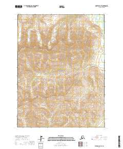
2017 Map of Wiseman B-2 SW
USGS Topo · Published 2017About this map
Gates of the Arctic National Park encompasses the majority of this Alaskan wilderness, revealing a landscape defined by dramatic elevation changes and a network of high-altitude drainages. The topography is dominated by steep-sided ridges and narrow valleys where seasonal runoff feeds into specific watercourses like Ipnek Cr and Ruby Cr. In the northeastern corner, the North Fork Koyukuk River flows through a broader valley floor, representing a primary hydrological artery for this portion of the central Brooks Range. This 2017 survey illustrates the complex drainage patterns of the far north, where small tributaries such as Winnie Cr carve through remote terrain defined by the Public Land Survey System boundaries of t29n r15w and t28n r15w.
Find a feature on this map
9 named features on this map. Tap any name to fly to it.
Don’t see what you’re looking for? This feature index may not catch every label — zoom into the map to look around manually.
Map Details
Editions of this 2017 Wiseman B-2 SW Map
This is the sole edition of this map. No revisions or reprints were ever made.
Other maps of this area

1951 · Wiseman
USGS Topo · 1:250,000

1956 · Wiseman
USGS Topo · 1:250,000

1964 · Wiseman
USGS Topo · 1:250,000

1970 · Wiseman A-3
USGS Topo · 1:63,360

1970 · Wiseman A-2
USGS Topo · 1:63,360
1971 · Wiseman B-3
USGS Topo · 1:63,360
1971 · Wiseman B-2
USGS Topo · 1:63,360
2016 · Wiseman B-3 SE
USGS Topo · 1:25,000
2016 · Wiseman B-3 NE
USGS Topo · 1:25,000
2016 · Wiseman A-3 NE
USGS Topo · 1:25,000