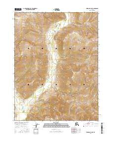
2016 Map of Wiseman B-3 NW
USGS Topo · Published 2016About this map
Mathews Dome rises as a prominent landmark in this interior Alaskan wilderness, overlooking a complex drainage system of high-altitude creeks. The landscape is defined by the winding course of the Wild River in the southwestern corner, which serves as the primary artery for the surrounding watershed. Numerous smaller tributaries, including Flat Cr and Birch Cr, carve through the terrain, illustrating the intricate hydrology of the Yukon-Koyukuk region. This 2016 survey captures the area in its modern state, showing a territory devoid of permanent settlements or roads, where the natural geography of James Cr, Rye Cr, and Jay Cr dictates the movement across the land. The map provides a clear look at the Public Land Survey System grids, specifically portions of t31n r18w and t30n r17w, which are essential for identifying specific land tracts in this remote part of the state.
Find a feature on this map
11 named features on this map. Tap any name to fly to it.
Don’t see what you’re looking for? This feature index may not catch every label — zoom into the map to look around manually.
Map Details
Editions of this 2016 Wiseman B-3 NW Map
This is the sole edition of this map. No revisions or reprints were ever made.
Other maps of this area

1951 · Wiseman
USGS Topo · 1:250,000

1956 · Wiseman
USGS Topo · 1:250,000

1964 · Wiseman
USGS Topo · 1:250,000

1971 · Wiseman C-4
USGS Topo · 1:63,360
1971 · Wiseman B-3
USGS Topo · 1:63,360
1971 · Wiseman C-3
USGS Topo · 1:63,360
1971 · Wiseman B-4
USGS Topo · 1:63,360
2016 · Wiseman C-3 SE
USGS Topo · 1:25,000
2016 · Wiseman B-4 SE
USGS Topo · 1:25,000
2016 · Wiseman B-3 SE
USGS Topo · 1:25,000