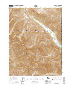
2016 Map of Wiseman B-6 NE
USGS Topo · Published 2016About this map
High-altitude drainage basins define this interior landscape within the Yukon-Koyukuk region, where the headwaters of Sixtymile Creek and Sixtymile Cr carve through steep, unnamed peaks. This 2016 survey highlights a remote wilderness devoid of permanent settlements or road infrastructure, focusing instead on the complex hydrography of the Brooks Range foothills. Several smaller tributaries, including Mettenpherg Cr, Colorado Cr, and Organ Cr, descend from the surrounding ridges into the primary valley systems. The map detail illustrates the transition between high alpine environments and the lower creek bottoms, providing a clear record of the area's natural drainage patterns and topographic relief for those studying the geography of the Alaskan north.
Find a feature on this map
9 named features on this map. Tap any name to fly to it.
Don’t see what you’re looking for? This feature index may not catch every label — zoom into the map to look around manually.
Map Details
Editions of this 2016 Wiseman B-6 NE Map
This is the sole edition of this map. No revisions or reprints were ever made.
Other maps of this area

1951 · Wiseman
USGS Topo · 1:250,000

1956 · Wiseman
USGS Topo · 1:250,000

1964 · Wiseman
USGS Topo · 1:250,000

1971 · Wiseman C-5
USGS Topo · 1:63,360
1971 · Wiseman B-5
USGS Topo · 1:63,360
1986 · Wiseman C-6
USGS Topo · 1:63,360
1986 · Wiseman B-6
USGS Topo · 1:63,360
2016 · Wiseman C-5 SW
USGS Topo · 1:25,000
2016 · Wiseman B-5 SW
USGS Topo · 1:25,000
2016 · Wiseman B-6 NW
USGS Topo · 1:25,000