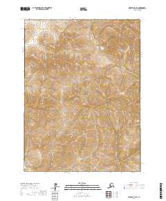
2017 Map of Wiseman C-2 SE
USGS Topo · Published 2017About this map
Gates of the Arctic National Park dominates this portion of the Alaskan interior, showcasing the intricate drainage patterns of the Brooks Range. The landscape is defined by the steep elevation gradients of the Yukon-Koyukuk region, where several significant watercourses shape the terrain. In the northern reaches, Willow Cr and Swede Cr flow through deeply incised valleys, while the southern part of the quadrangle is marked by Mascot Cr. On the western edge, the headwaters of Conglomerate Cr indicate the complex hydrology of this subarctic environment. The absence of roads or permanent structures reflects the primitive state of this wilderness in the early twenty-first century, serving as a baseline for environmental study and the preservation of large-scale natural systems.
Find a feature on this map
9 named features on this map. Tap any name to fly to it.
Don’t see what you’re looking for? This feature index may not catch every label — zoom into the map to look around manually.
Map Details
Editions of this 2017 Wiseman C-2 SE Map
This is the sole edition of this map. No revisions or reprints were ever made.
Other maps of this area

1951 · Wiseman
USGS Topo · 1:250,000

1956 · Wiseman
USGS Topo · 1:250,000

1964 · Wiseman
USGS Topo · 1:250,000

1971 · Wiseman C-2
USGS Topo · 1:63,360
1971 · Wiseman C-1
USGS Topo · 1:63,360
1971 · Wiseman B-1
USGS Topo · 1:63,360
1971 · Wiseman B-2
USGS Topo · 1:63,360
2017 · Wiseman C-2 SW
USGS Topo · 1:25,000
2017 · Wiseman C-1 NW
USGS Topo · 1:25,000
2017 · Wiseman B-2 NE
USGS Topo · 1:25,000