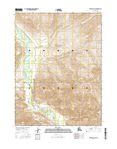
2016 Map of Wiseman C-5 SE
USGS Topo · Published 2016About this map
Gates of the Arctic National Park encompasses this portion of the central Brooks Range, where the drainage of the John River serves as a primary geographic corridor. This 2016 survey highlights a landscape defined by sharp elevation shifts and numerous alpine watercourses. Several significant creeks flow through the high-altitude terrain, including Sheep Cr and Eagle Cr in the southern sections, while the northern reaches are fed by Tangleblue Cr and the variously spelled Mashooshalluk Cr and Machooshalluk Cr. The map illustrates the Public Land Survey System grid across T31N and T32N, providing a rare look at the precise township and range demarcations within this protected wilderness area. The lack of permanent structures or roads emphasizes the primitive character of the park's interior during the early twenty-first century.
Find a feature on this map
11 named features on this map. Tap any name to fly to it.
Don’t see what you’re looking for? This feature index may not catch every label — zoom into the map to look around manually.
Map Details
Editions of this 2016 Wiseman C-5 SE Map
This is the sole edition of this map. No revisions or reprints were ever made.
Other maps of this area

1951 · Wiseman
USGS Topo · 1:250,000

1956 · Wiseman
USGS Topo · 1:250,000

1964 · Wiseman
USGS Topo · 1:250,000

1971 · Wiseman C-4
USGS Topo · 1:63,360

1971 · Wiseman C-5
USGS Topo · 1:63,360
1971 · Wiseman B-5
USGS Topo · 1:63,360
1971 · Wiseman B-4
USGS Topo · 1:63,360
2016 · Wiseman C-5 SW
USGS Topo · 1:25,000
2016 · Wiseman C-4 SW
USGS Topo · 1:25,000
2016 · Wiseman C-5 NE
USGS Topo · 1:25,000