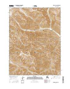
2016 Map of Wiseman C-6 NW
USGS Topo · Published 2016About this map
Gates of the Arctic National Park encompasses the majority of this territory in the central Brooks Range, where the topography is defined by the steep rises of the Endicott Mountains. The landscape is an intricate network of high ridges and narrow valleys, drained by the seasonal flows of Shukokluk Cr. This 2016 survey documents a wilderness largely untouched by permanent human infrastructure, focusing instead on the hydrography and elevation of the Arctic interior. The placement of township and range boundaries, such as t34n r24w and t33n r23w, provides the only structural grid over this protected landscape, illustrating how federal surveying methods are applied to one of the most remote regions in the United States.
Find a feature on this map
9 named features on this map. Tap any name to fly to it.
Don’t see what you’re looking for? This feature index may not catch every label — zoom into the map to look around manually.
Map Details
Editions of this 2016 Wiseman C-6 NW Map
This is the sole edition of this map. No revisions or reprints were ever made.
Other maps of this area

1951 · Survey Pass
USGS Topo · 1:250,000

1951 · Wiseman
USGS Topo · 1:250,000

1956 · Wiseman
USGS Topo · 1:250,000

1956 · Survey Pass
USGS Topo · 1:250,000

1964 · Survey Pass
USGS Topo · 1:250,000

1964 · Wiseman
USGS Topo · 1:250,000

1966 · Survey Pass
USGS Topo · 1:250,000
1986 · Wiseman C-6
USGS Topo · 1:63,360
1986 · Survey Pass D-1
USGS Topo · 1:63,360
1986 · Survey Pass C-1
USGS Topo · 1:63,360