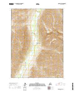
2017 Map of Wiseman D-2 SW
USGS Topo · Published 2017About this map
Gates of the Arctic National Park encompasses this expansive Brooks Range landscape, where the North Fork Koyukuk River carves a central valley between high-altitude terrain. The topography is defined by prominent peaks such as Boreal Mtn and the jagged Frigid Crags, marking the transition into one of the most protected wilderness areas in the United States. Tributaries including Kachwona Cr, Fishless Cr, and Pyramid Cr drain the surrounding mountains, reflecting a classic glacial-carved drainage pattern. This 2017 survey shows the river’s braided path through the valley floor, an essential corridor for seasonal travel and environmental study within the park's boundaries.
Find a feature on this map
12 named features on this map. Tap any name to fly to it.
Don’t see what you’re looking for? This feature index may not catch every label — zoom into the map to look around manually.
Map Details
Editions of this 2017 Wiseman D-2 SW Map
This is the sole edition of this map. No revisions or reprints were ever made.
Other maps of this area

1951 · Wiseman
USGS Topo · 1:250,000

1956 · Wiseman
USGS Topo · 1:250,000

1964 · Wiseman
USGS Topo · 1:250,000

1971 · Wiseman C-2
USGS Topo · 1:63,360
1971 · Wiseman D-2
USGS Topo · 1:63,360
1971 · Wiseman D-3
USGS Topo · 1:63,360
1971 · Wiseman C-3
USGS Topo · 1:63,360
2016 · Wiseman D-3 SE
USGS Topo · 1:25,000
2016 · Wiseman C-3 NE
USGS Topo · 1:25,000
2016 · Wiseman D-3 NE
USGS Topo · 1:25,000