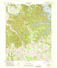
1978 Map of Wolf Creek Dam
USGS Topo · Published 1978About this map
The Wolf Creek Dam anchors this landscape where the Cumberland River meets the expansive waters of Lake Cumberland. Along the river's winding course, historical landmarks like Winfreys Ferry and the bottomlands of Rockhouse Bottom reveal the traditional importance of the waterway before the mid-century impoundment. The interior terrain is defined by complex ridges and hollows, such as Malone Hollow and York Hollow, which are dotted with dozens of Oil Wells, signaling the area's extraction history.
Find a feature on this map
63 named features on this map. Tap any name to fly to it.
Don’t see what you’re looking for? This feature index may not catch every label — zoom into the map to look around manually.
Map Details
Editions of this 1978 Wolf Creek Dam Map
3 editions found
Other maps of this area

1924 · Lillydale
USGS Topo · 1:62,500

1926 · Lillydale
USGS Topo · 1:62,500

1929 · Lillydale
USGS Topo · 1:62,500

1929 · Byrdstown
USGS Topo · 1:62,500

1953 · Amandaville
USGS Topo · 1:24,000

1953 · Burkesville
USGS Topo · 1:24,000

1953 · Wolf Creek Dam
USGS Topo · 1:24,000

1953 · Creelsboro
USGS Topo · 1:24,000

1953 · Jamestown
USGS Topo · 1:24,000

1954 · Frogue
USGS Topo · 1:24,000