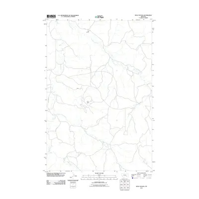
2011 Map of Wolf School
USGS Topo · Published 2011About this map
Sarpy Creek Mine dominates the central landscape of this Treasure County region, highlighting the industrial footprint within this part of Montana. The area is defined by the drainage systems of Sarpy Creek and its major tributaries, including East Fork Sarpy Creek and Middle Fork Spring Creek. These watercourses carve through a terrain marked by features like Bar Coulee, creating a complex network of ridges and valleys. Human presence is concentrated around the small settlement of Kuehn and along a system of rural routes such as Sarpy Rd and Castle Rock Rd. This survey provides a clear look at the intersection of large-scale mining operations and the natural hydrology of the Great Plains during the early 21st century, illustrating how industrial development and natural topography coexist.
Find a feature on this map
9 named features on this map. Tap any name to fly to it.
Don’t see what you’re looking for? This feature index may not catch every label — zoom into the map to look around manually.
Map Details
Editions of this 2011 Wolf School Map
This is the sole edition of this map. No revisions or reprints were ever made.
Other maps of this area

1954 · Hardin
USGS Topo · 1:250,000

1957 · Hardin
USGS Topo · 1:250,000

1958 · Hardin
USGS Topo · 1:250,000

1958 · Chalky Point
USGS Topo · 1:24,000

1967 · Jeans Fork NW
USGS Topo · 1:24,000

1967 · Jeans Fork NE
USGS Topo · 1:24,000

1971 · Mc Clure Creek
USGS Topo · 1:24,000
1971 · Sarpy School
USGS Topo · 1:24,000

1972 · Minnehaha Creek South
USGS Topo · 1:24,000
1972 · Iron Spring
USGS Topo · 1:24,000