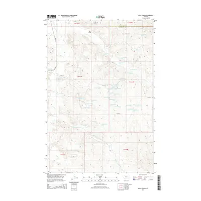
2014 Map of Wolf School
USGS Topo · Published 2014About this map
Wolf School sits as a solitary institutional landmark within the expansive terrain of the Little Wolf Mountains in southern Montana. This landscape, as it appeared in the early twenty-first century, is defined by the complex drainages of Sarpy Cr and its tributaries, including E Fork Sarpy Cr and Middle Fork Spring Cr. The land is divided by the boundary between Treasure Co and Big Horn Co, where the natural topography of ridges and coulees like Bar Coulee dictated the placement of rural infrastructure. Access through the region is maintained by a handful of corridors, most notably MT 384 and the winding Sarpy Basin Rd. The map illustrates a high density of natural springs, such as 01N38E30BBBC01 Spring, which are critical water sources in this semi-arid ranching and grazing environment.
Find a feature on this map
49 named features on this map. Tap any name to fly to it.
Don’t see what you’re looking for? This feature index may not catch every label — zoom into the map to look around manually.
Map Details
Editions of this 2014 Wolf School Map
This is the sole edition of this map. No revisions or reprints were ever made.
Other maps of this area

1954 · Hardin
USGS Topo · 1:250,000

1957 · Hardin
USGS Topo · 1:250,000

1958 · Hardin
USGS Topo · 1:250,000

1958 · Chalky Point
USGS Topo · 1:24,000

1967 · Jeans Fork NW
USGS Topo · 1:24,000

1967 · Jeans Fork NE
USGS Topo · 1:24,000

1971 · Mc Clure Creek
USGS Topo · 1:24,000
1971 · Sarpy School
USGS Topo · 1:24,000

1972 · Minnehaha Creek South
USGS Topo · 1:24,000
1972 · Iron Spring
USGS Topo · 1:24,000