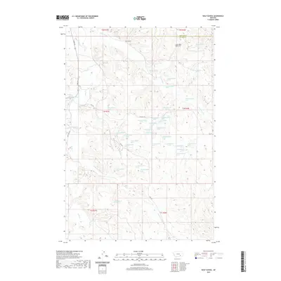
2020 Map of Wolf School
USGS Topo · Published 2020About this map
The Little Wolf Mountains dominate the northeastern portion of this Montana survey, where the border of Treasure and Big Horn counties cuts through the high ground. This area is characterized by its high concentration of named springs, such as 01N38E12ACDC01 Spring and 01N38E19CABB01 Spring, which feed into the complex drainage systems of E Fork Sarpy Cr and Middle Fork Spring Cr.
Find a feature on this map
49 named features on this map. Tap any name to fly to it.
Don’t see what you’re looking for? This feature index may not catch every label — zoom into the map to look around manually.
Map Details
Editions of this 2020 Wolf School Map
This is the sole edition of this map. No revisions or reprints were ever made.
Other maps of this area

1954 · Hardin
USGS Topo · 1:250,000

1957 · Hardin
USGS Topo · 1:250,000

1958 · Hardin
USGS Topo · 1:250,000

1958 · Chalky Point
USGS Topo · 1:24,000

1967 · Jeans Fork NW
USGS Topo · 1:24,000

1967 · Jeans Fork NE
USGS Topo · 1:24,000

1971 · Mc Clure Creek
USGS Topo · 1:24,000
1971 · Sarpy School
USGS Topo · 1:24,000

1972 · Minnehaha Creek South
USGS Topo · 1:24,000
1972 · Iron Spring
USGS Topo · 1:24,000