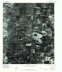
1976 Map of Wolfforth SW
USGS Topo · Published 1978About this map
Smyer stands as the primary hub of human activity within this orthophotoquad, centered in a landscape of high-plains agriculture on the Texas South Plains. Taken in the mid-1970s, the imagery reveals the striking geometric precision of West Texas farming, where the grid of rural roads and circular center-pivot irrigation patterns dominate the terrain. These circular signatures, many centered around natural playas or depressions, provide a clear record of the region's reliance on groundwater extraction during this era of agricultural intensification. The concentration of structures and street layouts in Smyer provides a distinct point of reference for genealogists and local historians tracking the development of small Hockley County communities during the late twentieth century.
Find a feature on this map
1 named feature on this map. Tap any name to fly to it.
Don’t see what you’re looking for? This feature index may not catch every label — zoom into the map to look around manually.
Map Details
Editions of this 1976 Wolfforth SW Map
This is the sole edition of this map. No revisions or reprints were ever made.
Other maps of this area

1954 · Brownfield
USGS Topo · 1:250,000

1957 · Meadow
USGS Topo · 1:62,500

1957 · Wolfforth
USGS Topo · 1:62,500

1958 · Brownfield
USGS Topo · 1:250,000

1962 · Brownfield
USGS Topo · 1:250,000

1964 · Whitharral
USGS Topo · 1:24,000

1965 · Levelland East
USGS Topo · 1:24,000

1965 · Lockettville
USGS Topo · 1:24,000
1976 · Wolfforth NW
USGS Topo · 1:24,000

1976 · Wolfforth SE
USGS Topo · 1:24,000