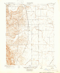
1917 Map of Wolfskill
USGS Topo · Published 1947About this map
The Rio De Los Putos defines the northern landscape of this region during the early twentieth century, where the foothills of the Coast Range meet the agricultural flats of the Sacramento Valley. This survey documents the specific rail infrastructure of the era, notably the Southern Pacific (Clear Lake Branch) which served the rural stops of Wolfskill and Allendale. Small, now largely forgotten junctions and sidings like Hardley and Violet appear along the tracks, providing precise locations for genealogists and local historians tracing the rail-oriented development of the county before the mid-century expansion of modern highways. The terrain transitions sharply from the elevated contours of Drakes Pt in the southwest to the orderly section lines of the Mt Diablo Meridian that organize the eastern plains, where Sweeney Creek and an unnamed Arroyo drain the upland slopes.
Find a feature on this map
12 named features on this map. Tap any name to fly to it.
Don’t see what you’re looking for? This feature index may not catch every label — zoom into the map to look around manually.
Map Details
Editions of this 1917 Wolfskill Map
2 editions found
Other maps of this area

1902 · Napa
USGS Topo · 1:125,000

1907 · Woodland
USGS Topo · 1:62,500

1908 · Vacaville
USGS Topo · 1:62,500

1915 · Merritt
USGS Topo · 1:31,680

1916 · Dixon
USGS Topo · 1:31,680

1916 · Winters
USGS Topo · 1:31,680

1916 · Maine Prairie
USGS Topo · 1:31,680

1917 · Wolfskill
USGS Topo · 1:31,680

1917 · Elmira
USGS Topo · 1:31,680

1921 · Mt. Vaca
USGS Topo · 1:62,500