
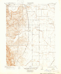
1917 Map of Wolfskill
USGS Topo · Published 1917About this map
The Southern Pacific railroad line, specifically the (Clear Lake Branch), cuts a sharp north-south path through this 1917 survey of Solano County. This rail corridor established the settlement pattern for the era, connecting the small stations and agricultural hubs of Hartley, Allendale, and Wolfskill. The landscape is defined by the transition from the steep, contoured hills near Drakes Pt in the southwest to the broad, flat plains of the Central Valley to the east. Along the northern edge, the Rio de los Putos creates a natural boundary, its meandering course contrasting with the rigid section lines of the Mt Diablo Meridian. The presence of small, named points like Violet at the base of the foothills illustrates the early 20th-century reliance on rail access for rural California communities before the expansion of the modern highway system.
Find a feature on this map
12 named features on this map. Tap any name to fly to it.
Don’t see what you’re looking for? This feature index may not catch every label — zoom into the map to look around manually.
Map Details
Editions of this 1917 Wolfskill Map
2 editions found
Other maps of this area

1902 · Napa
USGS Topo · 1:125,000

1907 · Woodland
USGS Topo · 1:62,500

1908 · Vacaville
USGS Topo · 1:62,500

1915 · Merritt
USGS Topo · 1:31,680

1916 · Dixon
USGS Topo · 1:31,680

1916 · Winters
USGS Topo · 1:31,680

1916 · Maine Prairie
USGS Topo · 1:31,680

1917 · Elmira
USGS Topo · 1:31,680

1921 · Mt. Vaca
USGS Topo · 1:62,500

1924 · Capay
USGS Topo · 1:62,500