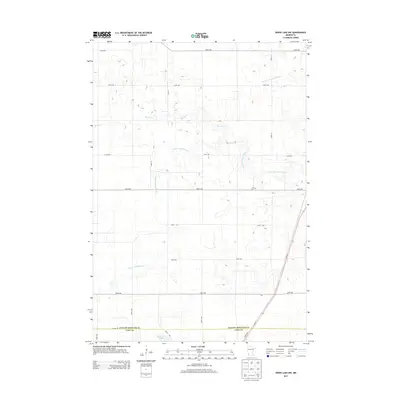
2013 Map of Wood Lake NW
USGS Topo · Published 2013About this map
The Yellow Medicine River winds through this agricultural landscape, forming a complex drainage network alongside Spring Cr and several managed watercourses like Br R County Ditch Number 9. This 2013 survey illustrates the highly structured rural grid of southwestern Minnesota, where a series of numbered avenues, including 240th Ave down to 170th Ave, organize the prairie. The boundary between Yellow Medicine Co and Lyon Co runs along the southern edge of the map, just north of Lone Tree Lake. A small burial site, identified simply as W Cem, serves as a localized landmark within the vast network of farm fields. Modern infrastructure is represented by the diagonal route of MN-23 cutting across the southeastern corner, providing a contrast to the rigid sectional lines that define the rest of the quadrangle.
Find a feature on this map
14 named features on this map. Tap any name to fly to it.
Don’t see what you’re looking for? This feature index may not catch every label — zoom into the map to look around manually.
Map Details
Editions of this 2013 Wood Lake NW Map
This is the sole edition of this map. No revisions or reprints were ever made.
Other maps of this area

1953 · New Ulm
USGS Topo · 1:250,000

1957 · New Ulm
USGS Topo · 1:250,000

1958 · New Ulm
USGS Topo · 1:250,000

1962 · Wood Lake NW
USGS Topo · 1:24,000

1962 · Cottonwood
USGS Topo · 1:24,000

1962 · School Grove Lake
USGS Topo · 1:24,000

1962 · Wood Lake
USGS Topo · 1:24,000

1965 · Clarkfield
USGS Topo · 1:24,000

1965 · Hazel Run
USGS Topo · 1:24,000
1965 · Granite Falls
USGS Topo · 1:24,000