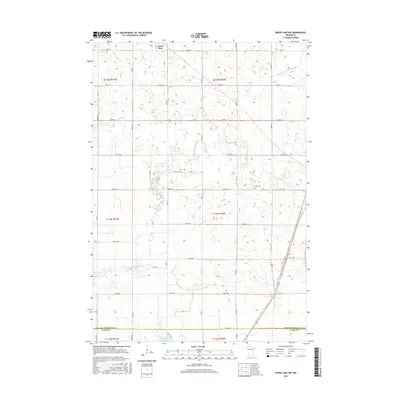
2016 Map of Wood Lake NW
USGS Topo · Published 2016About this map
Hazel Run sits in the northern reaches of this agricultural landscape in Yellow Medicine County, where the grid of sections is deeply established. The southern portion of the map transitions at the boundary of Yellow Medicine Co Lyon Co, following the path of Co Hwy 18 and Co Hwy 43. The terrain is defined by its water management and drainage, notably the meandering Yellow Medicine River and the engineered Br R County Ditch Number 9 to the northeast. Local history is anchored by West Cem, situated along the section lines east of the river. The map illustrates a highly organized rural infrastructure, where named routes like Co Hwy 3 and numerous numbered avenues provide access to the farmsteads and fields that have long shaped the regional economy.
Find a feature on this map
27 named features on this map. Tap any name to fly to it.
Don’t see what you’re looking for? This feature index may not catch every label — zoom into the map to look around manually.
Map Details
Editions of this 2016 Wood Lake NW Map
This is the sole edition of this map. No revisions or reprints were ever made.
Other maps of this area

1953 · New Ulm
USGS Topo · 1:250,000

1957 · New Ulm
USGS Topo · 1:250,000

1958 · New Ulm
USGS Topo · 1:250,000

1962 · Wood Lake NW
USGS Topo · 1:24,000

1962 · Cottonwood
USGS Topo · 1:24,000

1962 · School Grove Lake
USGS Topo · 1:24,000

1962 · Wood Lake
USGS Topo · 1:24,000

1965 · Clarkfield
USGS Topo · 1:24,000

1965 · Hazel Run
USGS Topo · 1:24,000
1965 · Granite Falls
USGS Topo · 1:24,000