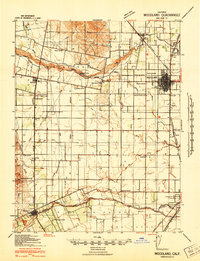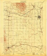
1907 Map of Woodland
USGS Topo · Published 1914About this map
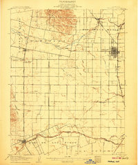
Woodland sits at the heart of this Central Valley landscape, serving as a hub for the extensive irrigation networks and rail lines that defined early twentieth-century Yolo County agriculture. The map illustrates a complex hydraulic system necessary for orchard and field crops, featuring the Adams Canal, Capay Canal, and the Moore Ditch diverting water from Cache Creek. These engineered waterways crisscross traditional land grants like Rio Jesus Maria and Guessisosi, showing the transition from Mexican-era ranchos to a modern industrial farming economy. Small rail-side settlements and spurs such as Citrona, Mill Spur, and Mullen trace the path of the Southern Pacific R R as it moved produce to market. To the south, the town of Winters marks the edge of the Rio De Los Putos grant along the banks of Putah Creek, while rural landmarks like Union School provide a glimpse into the community structure of this productive agricultural corridor.
Find a feature on this map
41 named features on this map. Tap any name to fly to it.
Don’t see what you’re looking for? This feature index may not catch every label — zoom into the map to look around manually.
Map Details
Editions of this 1907 Woodland Map
2 editions found
Historical Maps of Davis Through Time
9 maps found